Map Viewer Tutorial: How to Research Water Rights Using the Map Viewer
Finding information about your water rights can be difficult if you are not familiar with the resources maintained by the Colorado Department of Natural Resources. These tools can be accessed at https://dwr.state.co.us/tools.
The Map Viewer Tool is the best way to research a water right when you are trying to determine what, if any, water rights are associated with a particular piece of property.
Clicking on “Map Viewer,” as shown above, will take you to the following page.
We recommend that you select “Map Viewer–Full Version” to ensure that you have access to all of the data layers that you may need for your research
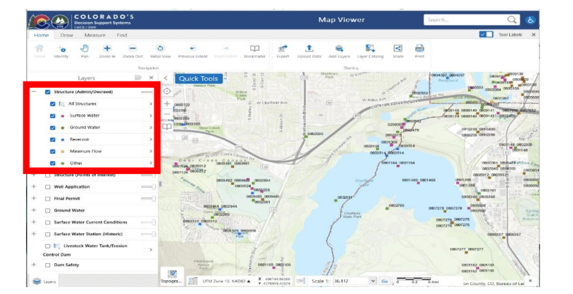
Clicking Map Viewer– Full Version will take you to the Map Viewer tool. As you will see, the left side of the screen displays a list of datasets that can be toggled on and off. Almost all of the data sets also have a “+” next to them, which if clicked, opens a dropdown menu with additional options. For purposes of this tutorial we are going to start by zooming in to our area of interest before turning on any data layers. We are going to look at the area around Chatfield Reservoir for this tutorial.
Once zoomed in, we will click the “+” next to the “Structure (Admin/Decreed)” data layer and clicked on all of the boxes in the dropdown menu. We did this to ensure that we were able to see all of the water rights in this area. If you were looking for information about the well permits in this area, you would need to open the dropdown menus for the “Well Application” and “Final Permit” datasets and click all of the available boxes. As you can see, there are many different water rights in this area. The different colors denote the different types of water right
The blue denotes water storage rights and clicking on the blue dot near the dam for Chatfield Reservoir brings up a text box that identifies the water right that is represented by the dot. Some dots include entries for multiple water rights. As shown in the red box below, there are six entries for this dot and you can cycle between them by clicking on the left and right arrows. To access detailed information about the water rights shown in the text box, you must click on “View Additional Details.”
Clicking on “View Additional Details” will replace the list of data sets on the left side of the screen with anew window specific to the water right. Clicking on the link displayed under “more info” will take you tothe structure page for Chatfield Reservoir.
Using the buttons at the top of the structure page, you can navigate the available data to learn more about this water right. The “Diversion Records” link will provide information about the amount of water diverted by the structure. The “Water Rights” link will list the water rights associated with the structure and provide information about the decreed uses, priority date, and relevant water court case numbers. The “Imaged Documents” tab allows you to access water court documents related to this structure and information exchanged with the Office of the Colorado State Engineer. These documents can be very valuable for understanding the scope and limitations of the water right and the history of its operation.
If you have specific questions about your water rights please reach out to any one of the experienced Water Attorneys at Nazarenus Stack & Wombacher LLC


